
Tracing Ashburn Residents
No single office keeps a complete household list for Ashburn. The community is an unincorporated Census-Designated Place within Loudoun County, so the useful trail is divided among county and state custodians. A parcel record can identify a recorded owner or taxpayer. A deed can show a transfer. A voter record can be inspected only through the process Virginia law permits. These are separate signals, and none alone proves that every person connected to an address lives there now.
Start with the detail already in hand. An address is usually the fastest route to a parcel and its PIN. A full name may work better in a court or historic index. For an older family question, pair the land trail with a library index, census microfilm, obituary, cemetery, or probate lead. The Ashburn residents directory is strongest when records are compared by date rather than collected as a loose list of names.
- Enter a known Ashburn address in the county real-property search. Record the PIN, situs address, recorded owner or taxpayer, legal description, subdivision, and any sale or deed reference.
- Open the same location in WebLogis. Confirm the parcel, tax map, road, ZIP label, election district, and related map layers before assuming that a postal label describes a legal boundary.
- Use the Clerk’s land-record index to follow the owner as grantee and the earlier seller as grantor. Save the instrument or book-and-page reference before asking for a copy.
- For a current registration question, use the voter’s own Citizen Portal access or ask the registrar about lawful public inspection under Virginia’s voter-record rules.
- When a public portal stops, narrow the request for the custodian. Historic Records can help with a specific reference, while the library and courthouse terminals provide the next practical route.
Note: Recorded ownership, a mailing address, and a current household are different facts that should not be treated as interchangeable.
Ashburn Resident Records Offices
Ashburn records are held mainly in Leesburg because Ashburn has no separate city clerk or municipal recorder. The Loudoun County Clerk of the Circuit Court keeps land, probate, marriage-license, and court materials. The Commissioner of the Revenue maintains the property assessment system. Mapping staff maintain the spatial layer that joins an address to a parcel. The elections office handles registration access. Together, these custodians provide a more reliable starting point than an unverified name list.
Historic Records & Deed Research
18 E. Market Street
Leesburg, VA 20176
703-737-8775
Commissioner of the Revenue
Loudoun County, Virginia
Real Estate Tax and Assessment
703-777-0260
Mapping & Geographic Information
1 Harrison Street SE, 2nd Floor
Leesburg, VA
703-771-5778
Loudoun Office of Elections
750 Miller Drive SE, Suite 150
Leesburg, VA 20175
703-777-0380
The Clerk’s Historic Records desk is especially important when a remote search gives only an index lead. It maintains land records from 1757 forward, courthouse terminals, historic PDF indexes, and copy-request channels. The mapping and assessment offices are better for locating a modern parcel first. The office sequence matters because an address lookup, a deed search, and a voter inspection are not versions of one shared database.
Ashburn Is a County CDP
“Ashburn” can appear as a Census-Designated Place, a postal place name, a subdivision name, or a label on a map. It is not an incorporated city with a separate Ashburn city clerk. That distinction prevents a common dead end: records for an Ashburn address generally belong with Loudoun County, even when an older document uses a nearby postal label or a different community name. The county seat and courthouse are in Leesburg.
Geography also changes how a name match should be checked. A ZIP, school zone, election district, subdivision, and parcel boundary can all describe the same vicinity in different ways. Use the address point and parcel record to confirm the county location, then preserve the source date. This is useful when a historic record says Leesburg while a newer mailing address says Ashburn.
Ashburn Property Records Routes
The Loudoun iasWorld address search is the county’s practical address-to-parcel route. It displays property and deed-related information, legal description, sale information, assessment values, and house characteristics after a search. The public interface is not presented as a broad owner-name lookup. Begin with an address, PIN, or tax-map clue instead, and keep the mailing address separate from the situs address. A mailing destination can be outside Ashburn and does not establish present occupancy.
The official address-search screen is shown in the Loudoun assessor address-search capture.
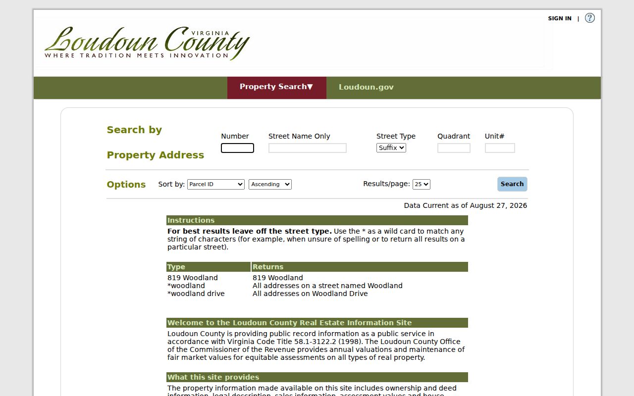
Use the result to establish the parcel record, then compare its PIN and legal description with the map and deed sources. The county states that assessment data is updated weekly, so retain the access date when a current detail matters.
Condominium garages and assigned parking may have their own PINs and assessments. A result can therefore describe a related unit or interest rather than the main parcel. That is another reason to read the legal description and property type before drawing a conclusion.
Note: A county owner or taxpayer field is a property-record fact, not a complete list of people at the address.
Ashburn iasWorld Record Fields
iasWorld offers more than one way to narrow an Ashburn search. The basic address screen accepts separate pieces of an address. The real-property screen also accepts PIN, land-use code, street number, street, ZIP Code, and a deactivated-accounts filter. The county instructs users to leave off a street suffix when needed and documents the asterisk as a wildcard. Advanced Search requires at least one added criterion and supports date, number, and range-style work without claiming that a person-name tab is public.
| iasWorld field | Type | Required | Use or format |
|---|---|---|---|
| Number | Text | No | Street number when known |
| Street Name | Text | No | Use a partial name or documented wildcard |
| Street Type | Selector | No | Omit to broaden a suffix-sensitive search |
| Quadrant and Unit # | Text | No | Add only when part of the address |
| PIN | Text | No | 12 characters; dashes may be omitted |
| ZIP Code | Text | No | Available from the real-property search |
The Advanced Search screen documents the criterion builder, Add, Edit, Remove, and distinct-results controls.
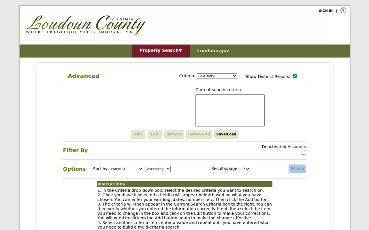
Its value is precision. A street, ZIP, or PIN can anchor the query before a search expands to a broader property characteristic. When a road name varies between sources, omit the suffix first or use the documented wildcard rather than guessing that the record is missing.
Ashburn Parcel Records Bridge
WebLogis bridges a street address and the property system. Enter the address, select the autocomplete suggestion, and then choose Locate on Map. Pressing Enter without selecting the suggestion can produce an error. The map can display address points, parcel boundaries, road centerlines, subdivisions, ZIP labels, zoning, floodplain, school, election, and other layers. From a parcel popup, the underlined PIN leads to the Commissioner’s assessment record.
WebLogis can also use a PIN or map-tile search and offers adjacent-parcel and distance tools. Parcel, address-point, and road-centerline layers are updated daily to the prior business day, while other layers follow their own metadata schedules. The map identifies land and record relationships. It does not create a roster of everyone in nearby homes. For a full street-by-street path, use the Ashburn street directory route after confirming the parcel.
- Parcel
- A defined piece of land used in assessment and mapping records.
- PIN
- The county’s parcel identification number, which can connect map and assessment results.
- Index
- A finding tool that points to a record or image; it is not always the document itself.
- Criss-cross directory
- An address-arranged directory that can provide a historical lead when an actual volume is confirmed.
Ashburn Deed Records Since 1757
Loudoun’s land-record history gives an Ashburn name or parcel a long paper trail, but access has several levels. The Clerk says public land research reaches from 1757 to the present at courthouse terminals. Occasional remote users may search the index without charge and purchase an image individually. An annual remote subscription costs $262 after approval and provides index and image viewing and downloading. At the courthouse, the kiosks are free during the listed weekday hours.
The remote land-record service shows the occasional, annual, and exempt access choices.
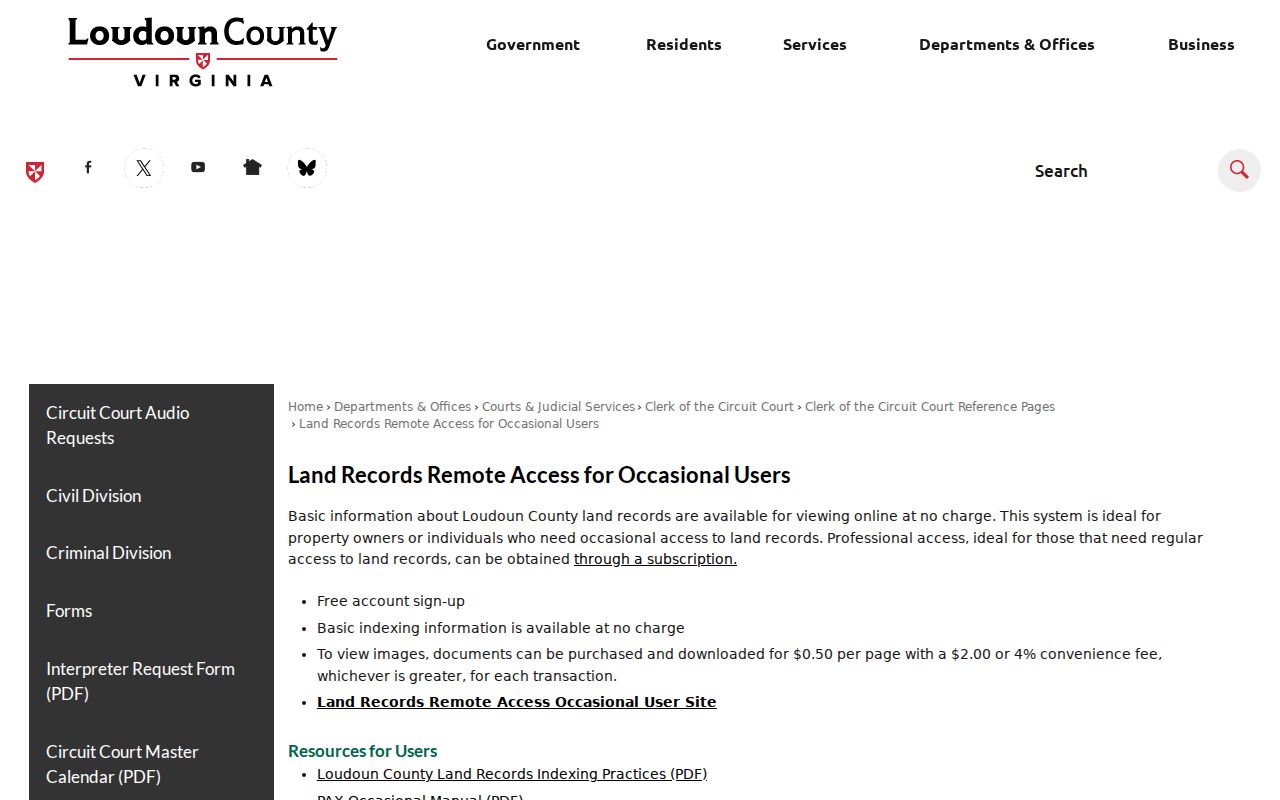
Remote availability does not establish that every historic book or image is online. When an index hit needs support, use the Clerk’s free kiosk, email or mail copy route, or contact Historic Records with the instrument number and page count. Staff can operate the access system but do not perform open-ended legal research.
Copies are listed at $0.50 per 8.5 by 11 or 8.5 by 14 page and $1.00 per 11 by 17 page. Certification adds $2 per document. A mail request needs the instrument or reference number, page count, chosen copy size, certification choice, payment, and a self-addressed stamped envelope.
The official deed-index series provides six downloadable runs from 1757 through 1903, plus partially proven wills-and-deeds and plat-reference indexes.
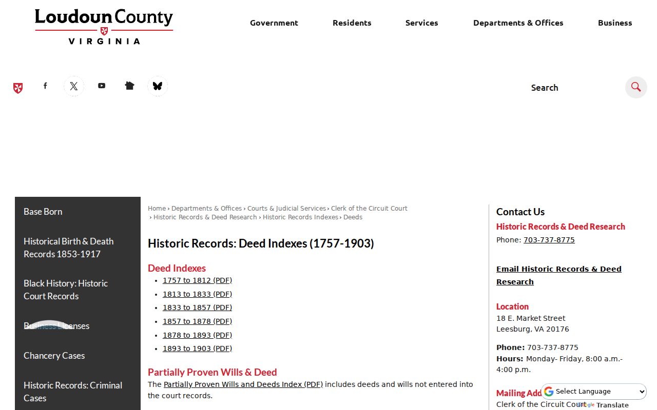
Those indexes make a careful historic search practical: note the grantor, grantee, series, book or page reference, recording clue, and any linked plat reference before seeking the underlying record. The historic reach is a local strength, not a promise that every remote result contains a complete image.
Official records should lead whenever the source and date matter. The commercial people-finder category can compile property, voter, court, marketing, and other data into a paid report, but it can also retain stale addresses, merge similar names, or omit protected records.
| Source category | Best use | Limit to remember |
|---|---|---|
| Official county or state record | Confirm the custodian, record type, reference, and access date | Each source answers a narrow question and may have confidentiality limits |
| Commercial people-finder category | Generate a lead that must be checked against the original custodian | Compiled data can be old, inaccurate, or attached to the wrong person |
Note: An index hit and a certified or original record have different access routes and should be kept as distinct evidence.
Ashburn Residents Directory Sources
Current Ashburn resident directories are really a group of records with different audiences. Property assessment results identify a recorded property relationship. A voter list is governed by its own statute. Deed and court indexes list parties to transactions or cases. Permit records can tie a project to an address and PIN. The table separates what each source can confirm from what it cannot safely imply.
| Current source | What it may show | Custodian | Access route |
|---|---|---|---|
| Real-property assessment | Recorded owner or taxpayer, mailing and situs address, legal parcel details | Commissioner of the Revenue | Free iasWorld address, PIN, tax-map, and ZIP search |
| Parcel and map layers | PIN, parcel geometry, address point, roads, districts, and map context | Mapping & Geographic Information | Free WebLogis search and office computers |
| Land-record index | Grantor, grantee, instrument, legal description, and plat leads | Circuit Court Clerk | Free index, paid individual images, free courthouse kiosk |
| Voter registration list | Statutorily permitted registration fields and election districts | Department of Elections and local registrar | Own-record portal or lawful public inspection |
| Permit and plan records | Address, PIN, permit number, issue timing, unit, and project context | Building & Development | LandMARC and issued-permit reports |
For a name that appears in more than one source, compare the record date, full name form, property identifier, and document type. A resident lookup is more dependable when a property result, a public index, and a clerk-held record lead to the same person at the relevant time.
Ashburn Voter Records Limits
The Virginia Citizen Portal is for a voter to check their own registration, polling place, districts, absentee status, and voting history. Its status flow asks for first name, last name, full date of birth, last four digits of the Social Security number, locality, and a certification. Those identity-check fields are not a public invitation to search another person’s record.
Virginia Code § 24.2-444 allows inspection of listed voter fields including name, address, year of birth, gender, and applicable election districts, while excluding Social Security information, day and month of birth, registration-agency information, and certain protected addresses. The Loudoun registrar maintains the local inspection route. A person may be absent because they are not registered, moved, used a protected address, or have a differently indexed name. No voter result reveals how anyone voted.
Note: Voter registration can corroborate a lawful record match, but it is not an all-resident directory or a household census.
Ashburn Court Lookup Limits
Virginia General District Court case information requires selecting one court, so choose Loudoun General District Court rather than assuming a statewide name search. The portal supports a required last name, optional first and middle names, a case number, or a hearing date. Wildcards are allowed in name fields with at least two other characters. Use Current, Archived, or All when the relevant period is unknown. Current data is described as after January 2007 and archived data as before January 2007.
A result may show the party name, case number, category, hearing date, locality, status, and entered case details. It is not an identity certificate. Compare name forms and any lawfully visible context before linking a docket to an Ashburn resident. Loudoun Circuit records use locality-specific court access, and there is no one statewide circuit search. Sealed, expunged, medical, protective-order, juvenile, and domestic-relations material is not an ordinary public name search.
Ashburn Vital Record Windows
The Virginia Department of Health Office of Vital Records holds Commonwealth birth, death, marriage, and divorce records. Its genealogy indexes can provide an event lead, not an unrestricted certificate. Under Virginia Code § 32.1-271, birth records become public after 100 years. Death, marriage, and divorce records become public after 25 years. Before those periods end, certified copies are generally limited to immediate family with identification, subject to the stated rules.
VDH lists online, mail, Richmond walk-in, participating local-health-district, and express delivery channels. The standard fee is $15 per certificate or search, including a search with no located record. For older Loudoun family research, Thomas Balch Library and the Library of Virginia provide local and state index, microfilm, and archival routes. An index entry still needs a date, place, and the right custodian before it becomes a usable record request.
Ashburn Residents Directory Privacy
Public records have boundaries. The Virginia Address Confidentiality Program protects the physical location of eligible survivors who have relocated, using a substitute address and mail forwarding. A protected address must not be inferred from a parcel, voter, motor-vehicle, or court record. Virginia’s consumer-data law also gives qualified consumers rights to seek access, correction, deletion, and certain opt-outs from covered controllers, subject to authentication and statutory exceptions.
When an official record seems wrong, save the source URL and access date, then contact the creating agency for its correction, redaction, or sealing process. Virginia FOIA is a fallback for public county administrative records, not a way around voter, vital-record, court, motor-vehicle, or confidentiality rules. Under Virginia FOIA § 2.2-3704, a public body must respond within five working days by producing records, estimating a response, denying with a citation, or using another permitted response.
Ashburn Records Survived 2001
The 2001 courthouse-complex fire is a useful provenance note for Ashburn historical research. Loudoun’s county history reports that the historical court record was not destroyed. That does not mean every item is digitized, easy to search, or open for every purpose. It does explain why a long local run can still connect deeds, wills, tax material, criminal papers, and court indexes across periods that are missing in many counties.
Loudoun separated from Fairfax in 1757, and the county’s Historic Records collection begins with that formation period. Later preservation and digitization work included land-tax books, will books, an early deed book, and criminal-paper series. Use the historical timeline to choose the right county and record type, then verify whether the needed image is online, at the courthouse, or in an archive. Old farm, village, and subdivision names may require a plat, legal description, or tax-map bridge before they resemble a modern Ashburn address.
Note: A courthouse-history detail explains record provenance; it never substitutes for the cited record, index, or original image.
Ashburn Historical Resident Directories
Historical Ashburn resident directories are best approached through the wider Loudoun collection rather than by assuming a separate city series. Thomas Balch Library in Leesburg holds local census material, deed and will resources, maps, newspapers, tax rolls, cemetery information, family files, historic-house files, and other non-circulating research materials. Its collections can turn a surname or old road name into a precise archival lead.
The inspected sources confirm directory, gazetteer, and reverse-directory research as useful local collection work, but they do not publish a defensible complete list of Ashburn or Leesburg directory titles and years. Confirm a specific volume in the catalog or at the reference desk before relying on it. A criss-cross volume may connect an old address to a household lead; census, deed, probate, obituary, and cemetery sources then help test the date. The historical collection is explored in more depth through the Ashburn city directory materials.